

The Missile Crescent - Can China's Navy Break Out?
Land-Based Sea Denial and China's PLA Navy’s (PLAN) Maritime Breakout Problem
An InfinIdea Strategic Working Paper
Can the world's largest navy reliably reach the open Pacific and Indian Oceans when the maritime exits from China's near seas are increasingly exposed to mobile land-based anti-ship missile capabilities?

The "Missile Crescent": land-based anti-ship missile capabilities ringing China's maritime approaches, from the Ryukyus to northern Australia. Conceptual illustration by Team InfinIdea.
The "Missile Crescent" is an analytical concept used in this paper to describe overlapping land-based maritime-denial capabilities around China's maritime approaches. The illustration and framework are conceptual and are not intended to represent a permanently closed maritime barrier.
Executive Assessment · China has built the world's largest navy by hull numbers. That achievement matters, but fleet size alone does not determine naval power. A surface fleet also needs room to disperse, maneuver, sustain operations and reach open water before it can fully exploit its numbers and weapons. · The People's Liberation Army Navy (PLAN) has progressively expanded its ambitions beyond China's near seas toward the wider Pacific and Indian Oceans. Yet the routes connecting China's coastal waters with those oceans are shaped by geography. Several of the most useful exits pass through straits, island chains and relatively constrained maritime corridors. · Around these approaches, Japan, Taiwan, the Philippines, Vietnam, Indonesia, India and Australia are operating, acquiring or developing land-based anti-ship and related maritime-denial capabilities. Considered individually, none of these systems necessarily determines the fate of the PLAN. Considered collectively, and networked effectively, however, they could increase the cost, uncertainty and operational complexity of a Chinese naval breakout in a multiplied scale. · This paper calls that emerging pattern the "Missile Crescent." The concept is less about a continuous wall of missiles than about overlapping pockets of risk extending from the Ryukyus and Taiwan Strait through the South China Sea and Indonesian approaches toward northern Australia. · The central argument is therefore straightforward: the strategic value of regional land-based anti-ship missiles may lie not in their ability to destroy the PLAN outright, but in their ability to make maritime transit sufficiently hazardous and costly, that Chinese surface force fleets may not be able to get out to the open waters of the Indian and Pacific Oceans, retaining sufficient hull numbers to offer desired combat potentials and strategic effects. · The PLAN surface vessels might require greater protection, alternative routes and more extensive supporting forces – OR, they may need to opt for alternative low-profile asymmetric methods to deal with the threats and be able to exercise their full combat potential without significant attrition and avoid drawing attention by its adversaries at the outset of any impending conflict. This is a potential strategic scenario and assessment, not a prediction of future conflict. The paper uses open-source information and deployment descriptions and does not claim that any maritime route can be permanently closed. |
The Central Question If the PLAN cannot reliably break out from the near seas, can the world's largest navy fully exploit its fleet potentials? The issue is not whether one missile battery can defeat a Chinese task force. The more consequential question is whether multiple, geographically dispersed land-based missile networks can collectively make a naval breakout dangerous, uncertain and costly enough to constrain Chinese power projection. |
Watch the Video analysis:
1. The PLAN's Maritime Breakout Problem
A modern navy gains important advantages when its ships reach open water. Space allows forces to disperse, complicates surveillance and targeting, creates room for maneuver and reduces the vulnerability associated with predictable routes. Those advantages become harder to realize in narrow seas, littoral zones and chokepoints.
China's naval development has increasingly reflected the objective of operating beyond the immediate coastal environment — first "near seas control" out to the First Island Chain, then, from China's 2015 military strategy white paper onward, a combined posture of "offshore waters defense" and "open seas protection" meant to carry Chinese naval power into the Pacific and Indian Ocean as a matter of routine, not exception. This paper's underlying premise is that the PLAN's growing far-seas role makes access to the wider Pacific and Indian Oceans strategically important rather than merely desirable.
The challenge is that access is not determined by fleet size alone. A large fleet still has to pass through geography. If a force must repeatedly negotiate constrained exits while exposed to land-based missiles, aircraft, submarines, surveillance networks and other supporting systems, the value of numerical superiority can be reduced.
The consequence of a failed breakout would not necessarily be the physical destruction of the entire PLAN. A more plausible strategic effect would be concentration. Surface forces remaining in the Yellow Sea, East China Sea and South China Sea could become more predictable and therefore more exposed to overlapping threats from hostile undersea forces, shore-based anti-ship assets and combined airpower operating with a strong geographical advantage.
The economic dimension is equally important. China relies on maritime imports through the Indian Ocean and the Malacca Strait for an estimated 70–80% of its crude oil, and the paper highlights the importance of these routes and other sea lines of communication (SLOCs). If Chinese naval forces were unable to protect distant shipping or overseas interests — from the military base in Djibouti to the Ream Base presence in Cambodia and commercial ports under the Belt and Road Initiative — the strategic consequences could extend well beyond the fleet itself, toward energy rationing, raw-material shortages and industrial disruption at home.
This does not mean a regional missile network could automatically impose a blockade or permanently sever China's SLOCs. It means that the cost of protecting those routes could rise substantially if the PLAN had difficulty reaching the wider maritime spaces in which a blue-water fleet operates most effectively.
2. The Missile Crescent Takes Shape
The Missile Crescent is this paper's central analytical concept. It describes an arc of potential land-based maritime-denial capabilities running from the Ryukyu Islands and Taiwan Strait, through the South China Sea and Indonesian archipelago, toward Australia's northern approaches — with India's Andaman and Nicobar Command adding an important western component near the Malacca approaches.
The concept rests on a simple geographic observation: the PLAN's routes to the open ocean are not equally unconstrained in every direction. A series of island chains and maritime passages creates points where land-based systems can potentially influence naval movement.
Japan, Taiwan, the Philippines, Vietnam, Indonesia, Australia and India do not constitute a single military alliance for the purposes of this analysis. Their systems differ in range, doctrine, readiness, command arrangements and political circumstances. The "crescent" is therefore a geographic and analytical description, not an assertion of unified wartime command.

The strategic effect emerges from overlap. A ship that leaves one threat zone will likely enter another. A task force that avoids one chokepoint may have to consider an alternative route with its own surveillance and missile risks. This creates a planning problem for the naval force even when no individual battery is decisive — echoing the broader logic of anti-access/area-denial (A2/AD), the very concept Beijing itself built to keep the U.S. Navy at arm's length.
By 2026 that ring had widened into a genuine pincer: the U.S.-supplied Typhon and Indian-designed BrahMos systems in the Philippines, Indonesian BrahMos, Australia's Naval Strike Missiles (NSM/NMESIS), India's fortified Andaman and Nicobar Command, Japan's extended-range Type-12 missile belt along the Ryukyus, Vietnamese P-800 Oniks and BrahMos batteries, and Taiwan's expanding Hsiung Feng III batteries around the strait itself. Together they close the loop from the Miyako Strait to the Malacca approaches and down to the Timor Sea–Arafura Sea–Coral Sea alternative passage between Indonesia and Australia.
3. Vietnam — The Western Rim of the South China Sea
Vietnam provides an important western component of the South China Sea portion of the concept. Hanoi has run the K300P Bastion-P since the early 2010s — a truck-mounted system firing the P-800 Oniks, a 3-ton supersonic missile that climbs high off the pad, then dives to skim the waves at 5–15 metres, switching on its own radar only in the final stretch. One battery reaches approximately 300 km and covers 600 km of coastline.
Vietnam has since added Indian BrahMos on top — a Mach 2.8–3.0 missile out to 300–400 km, now also in Philippine and Indonesian hands — lining both rims of the South China Sea with launchers that can strike a warship before it knows it is being tracked.


P-800 Oniks (left) and BrahMos (right)

The strategic significance is not simply the nominal range of a missile. A mobile battery can complicate surveillance, route planning and force protection, especially when supported by other sensors and military assets. Vietnam therefore represents the western rim of the South China Sea component of the Missile Crescent, adding another potential layer of risk for surface forces attempting to move through the region.
4. The Philippines — Typhon and the Bashi Corridor
The Philippines occupies a particularly important geographic position between the South China Sea and the wider western Pacific. Manila has acquired BrahMos from India and hosts the U.S.-deployed Typhon Mid-Range Capability system, which fired a live Tomahawk Land Attack Missile during Exercise Balikatan 2026 — a roughly 600 km shot from Tacloban Airport in Leyte to a target at Fort Magsaysay in Nueva Ecija, the first such live fire in the Philippines since Typhon's 2024 deployment. Typhon also carries the SM-6 for a shot at anything trying to slip past.
The U.S. Marines' NMESIS launchers, positioned in the Batanes islands facing the Bashi Channel with Norwegian-made Naval Strike Missiles (NSMs) out past 180 km and a smart seeker, offer enough precision to pick the right ship out of a crowd. The corridor linking the open Pacific to the South China Sea has become considerably less comfortable for the PLAN.


The key point is cumulative rather than absolute. Different systems have different ranges and missions, and their actual wartime effectiveness would depend on intelligence, surveillance, targeting, survivability, air defence and rules of engagement. Nevertheless, their presence adds another layer to the PLAN's breakout problem.
5. Japan — The Type-12 Extended-Range Challenge
Japan's geography makes the Ryukyu chain especially relevant to the maritime-breakout question. Tokyo's upgraded Type-12 — the same coastal anti-ship missile Japan has fielded since the 1990s — has been rebuilt with a turbofan cruise stage stretching its range from roughly 200 km to about 1,000 km. The upgraded missile became operational in March 2026 at Camp Kengun in Kumamoto Prefecture and Camp Fuji in Shizuoka, with further deployment planned at Oita, Okinawa's Ishigaki, and eventually Yonaguni — Japan's westernmost island, in sight of Taiwan.
The target set is explicit: the Miyako Strait, the deep-water gap through the Ryukyu chain that PLAN task forces must cross to break into the open Pacific or move to blockade Taiwan from the east. At full extension the missile can reach parts of the Chinese mainland directly, giving Tokyo a genuine standoff counterstrike option for the first time under its post-war defense posture.


The figure of roughly 1,000 km should be treated as an open-source analytical value rather than a guaranteed combat envelope; actual effectiveness would depend on launch conditions, targeting information, missile configuration, electronic warfare and the survivability of the launcher. Even so, as Japan increases the reach and distribution of its land-based systems, the Ryukyus become more than a geographic boundary — they can also function as a potential maritime-denial line.
6. Taiwan — Thickening the Strait
Taiwan's geography places it at the center of the northern portion of the Missile Crescent. The Hsiung Feng III, Taiwan's first supersonic anti-ship missile and a program running since 1994, already forms the backbone of the navy's Coastal Combat Command, fielded on Cheng Kung-class frigates, Tuo Chiang-class corvettes and mobile land batteries out to roughly 150–250 km. The strategic value of these systems is tied to the Taiwan Strait and surrounding waters. A dense coastal missile network could complicate any attempt by a surface force to operate near the island or to use the strait as a predictable transit corridor.
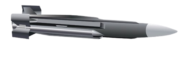
The newer extended-range HF-3ER, publicly deployed for the first time during the Han Kuang 41 exercises in July 2025 near Taipei Port, stretches that to around 400 km. Production has accelerated to roughly 70 missiles a year, backed by an NT$44.1 billion production line, with a further batch of 232 additional Hsiung Feng systems approved in 2025 to raise resistance to jamming and improve lethality.
Combined with incoming U.S. Harpoon coastal batteries, Taiwan's land-based anti-ship inventory is on track to become among the densest coastal missile concentrations anywhere, organized under a new Littoral Combatant Command established in 2026 to bring coastal-defence anti-ship units under one command for multilayered saturation strikes. The strategic logic is blunt: saturate the strait densely enough that a PLAN invasion fleet loses a meaningful share of its hulls before it ever reaches the beach.

7. Indonesia — The Southern Doors
Indonesia is important because it controls or influences several alternative maritime passages south of the Malacca Strait, including the Sunda, Lombok and Makassar routes — the backup doors for China if the more direct route becomes crowded. Jakarta's recent acquisition of shore-based BrahMos supersonic cruise missile batteries creates significant tactical and strategic problems for the PLAN surface fleet, forming an Anti-Access/Area Denial (A2/AD) zone along the southern approaches to the South China Sea.

Indonesia therefore adds a southern dimension to the Missile Crescent. Its significance is not that every passage would necessarily be closed, but that route selection becomes a more complicated strategic calculation for a transiting force.
8. Australia — The Southern Anchor
Australia provides the southern anchor of the concept. The planned StrikeMaster Coastal Defence System — Naval Strike Missiles mounted on modified Bushmaster vehicles, developed jointly by Kongsberg and Thales — successfully completed live-fire testing in Norway in October 2025 and is slated to protect Australia's vast maritime approaches, particularly the narrow sea lanes between the northern coast and Indonesia and Papua New Guinea.

The NSM will be manufactured at the new Kongsberg missile factory under construction at Williamtown, near Newcastle, with deliveries expected to commence in 2027 — supporting a sovereign Australian production line alongside Thales's Bushmaster line at Bendigo. As with other program timelines, 2027 should be understood as a planning assumption rather than a guarantee.
9. India — The Western Gate
India's Andaman and Nicobar Command (ANC) occupies a strategically important position near the western approaches to the Malacca Strait, the principal maritime corridor connecting the South China Sea with the Indian Ocean. The islands provide India with a location from which maritime movement can be monitored and, in a conflict, potentially influenced through a combination of naval, air and land-based capabilities.

The BrahMos family of land-based anti-ship systems, where deployed and within effective engagement parameters, sits within a broader architecture that includes aircraft, naval forces, unmanned systems and intelligence, surveillance and reconnaissance assets. India has continued to expand this posture: Sukhoi-30MKI fighters armed with BrahMos now operate from an upgraded Car Nicobar runway, a second airfield is being developed on Great Nicobar Island overlooking the Malacca approaches, and INS Baaz at Campbell Bay is being expanded for special-operations and maritime-surveillance aircraft.
The central strategic advantage is therefore not necessarily the ability to "close" the Malacca Strait — a more defensible interpretation is that the Andaman and Nicobar position can raise the operational risks, planning requirements and potential attrition costs for a hostile naval force attempting to move between the Indian Ocean and the South China Sea. Chinese naval forces could respond by dispersing, employing submarines, increasing air-defence and electronic-warfare measures, or using alternative Indonesian passages such as the Lombok and Makassar Straits. Maritime denial is not the same as permanent closure; effectiveness depends on the ability to detect, track and engage relevant targets and to sustain those capabilities under wartime pressure.
Missile Crescent — Capability Snapshot
System | Country / Operator | Reach stated in paper | Principal strategic relevance |
Bastion-P / P-800 Oniks | Vietnam | ~300 km | South China Sea |
BrahMos | India, Vietnam, Philippines, Indonesia | 300–400 km | Regional sea denial |
NSM / NMESIS | Australia / US–Philippines (Batanes) | ~185 km | Littoral / chokepoint defence |
Typhon (Tomahawk + SM-6) | Philippines | 1,600+ km | Long-range strike |
Type-12 ER | Japan | ~1,000 km | Ryukyu / Miyako approaches |
Hsiung Feng III / HF-3ER | Taiwan | 150–400 km | Taiwan Strait |
Andaman & Nicobar Command | India | Multi-domain | Malacca approaches |
Note: ranges and deployment descriptions above are those used in this working paper and should be understood as open-source analytical estimates rather than guaranteed wartime engagement envelopes.

10. What Happens If the PLAN Cannot Break Out?
· Risky Concentration
If surface forces remain largely confined to the near seas, their operating areas become more predictable. They lose some of the dispersal advantages associated with open-ocean maneuver and may have to operate under a denser combination of land, air- and sea-based surveillance and strike threats.
· Attrition
Concentration can increase exposure to overlapping threats. The critical point is not that every missile will find its target, but that the defending side can create repeated dilemmas involving surveillance, air defence, electronic warfare, decoys and route selection.
· Strategic Containment
A persistent inability to reach open waters could constrain China's ability to protect distant sea lines of communication and overseas interests. The consequences would extend beyond individual naval engagements to questions of energy security, commercial shipping and the protection of overseas facilities. This would invariably, at some stage negate the PLAN’s dominance, allow the US and its allies to control the seas – which might seriously hamper China’s quest for the “Great rejuvenation of the Chinese nation”.
11. How Would China Respond to the Missile Crescent?
China would not necessarily have to defeat every missile battery individually. It could instead seek to reduce the effectiveness of the network by attacking the conditions that make land-based sea denial work: detection, tracking, command, communications, targeting and the survivability of launchers and supporting infrastructure.
The paper considers utilization of distributed unmanned systems and electronic warfare as one possible broad line of low-yield response – without prematurely triggering a full-fledged conflict, until all-out war breaks out. Low-cost unmanned platforms could potentially complicate surveillance and defensive decision-making by creating more objects to detect and classify — expendable decoys, electronic-warfare systems, reconnaissance platforms and other unmanned aerial or sea-borne assets designed to overload, confuse and neutralize portions of a coastal defence network. The objective would be to create temporary gaps rather than necessarily destroy the entire network.


Maritime militia vessels (left) and container-configured civilian shipping (right)

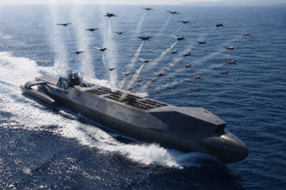
Unmanned "drone mothership" concept (left) and an unmanned surface trimaran concept (right)
The paper also considers the possible use of civilian or auxiliary maritime platforms as launch or support nodes. Such concepts would, however, raise serious legal, escalation and civilian-safety concerns. They should therefore be treated as strategic possibilities for analysis rather than as immediately executable operational recommendations.

The broader Chinese response could also include submarines, airpower, electronic warfare, deception, alternative routes and efforts to disperse naval forces. The result would be a contest between the defender's geographic advantage and the PLAN's ability to create enough operational freedom to reach open water.
12. The Real Contest: Mass versus Geography
The Missile Crescent does not depend on the assumption that regional states can defeat the PLAN in a conventional fleet-on-fleet contest. Its logic is different: a relatively inexpensive mobile missile system can impose a disproportionately expensive planning problem on major surface fleets. The defending force does not necessarily have to destroy every ship — it may gain strategic value simply by forcing the naval force to devote more resources to reconnaissance, escorts, air defence, electronic warfare, route clearance and deception.
This creates a contest between naval mass and geographic denial. China's numerical advantage can generate enormous combat power, but geography determines where that power can be brought to bear. The central question is consequently not whether China can defeat a single missile battery — it is whether the PLAN can create and maintain enough freedom of movement to cross several potentially contested maritime corridors and emerge into open water.
Analytical Note This working paper presents a strategic scenario and assessment rather than a prediction of future conflict. Missile ranges, deployment locations, sensor performance, targeting effectiveness, survivability, readiness, rules of engagement and wartime conditions may differ substantially from open-source estimates. The term "Missile Crescent" is used here as an analytical concept describing overlapping potential sea-denial capabilities. It should not be interpreted as a permanently closed maritime barrier or as evidence of a unified military command among the countries discussed. The paper also does not attempt to model the full order of battle of the PLAN or the complete defensive and offensive capabilities of the countries involved. Its purpose is narrower: to examine how geography and distributed land-based anti-ship capabilities could influence the strategic problem of Chinese maritime breakout. Final AssessmentThe PLAN does not necessarily need to defeat every land-based missile battery surrounding China's maritime approaches. It needs to break through the network sufficiently to reach open water and retain operational freedom. That distinction is central to the Missile Crescent concept. A dispersed network of mobile launchers does not have to destroy China's fleet outright to produce strategic effects — it can raise uncertainty, increase escort requirements, complicate route planning and impose additional demands on naval air defence, electronic warfare and supporting forces. If the PLAN's surface fleets were unable to break out into the open waters of the Indian and Pacific Oceans during a major conflict, the consequences could extend well beyond individual naval engagements. China's ability to protect distant SLOCs, support overseas interests and project sustained maritime power could be constrained. The strategic competition therefore becomes a contest between naval mass and geographical denial. The question is not whether the PLAN can defeat one missile battery. It is whether it can break through the geography of the Missile Crescent 🎧 Listen to the full paper: The Missile Crescent - Land Based Sea Denial And China's PLA Navy's (PLAN) Maritime Breako |
About Team InfinIdeaInfinIdea is a geostrategy, military technology and public policy focused platform built around the idea of: Fact. Analysis. Idea. Impact. Methodological Note: This working paper reflects the analysis and judgments of Team InfinIdea. Open-source research and AI-assisted research and writing tools were used where appropriate for information gathering, organization and editorial support. The final framing, arguments, interpretations and assessments are the responsibility of Team InfinIdea. Readers should independently verify time-sensitive technical and deployment information before relying on it for professional purposes. |


Comments